Mount Merapi Yogyakarta is not a backdrop. It’s the most active volcano in Indonesia, has erupted significantly multiple times in the past two decades, and shapes the landscape, culture, and daily risk awareness of the city in its shadow in ways that most visitor guides treat as a footnote. This is the fuller version — what Merapi actually is, what it means for a Yogyakarta visit, and how to engage with it honestly rather than from a safe distance.
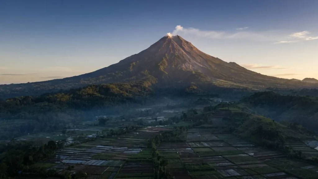
Mount Merapi Yogyakarta sits 28 kilometers north of the city center and is visible from much of the city on a clear day — a perfectly conical volcanic peak rising above the surrounding highland landscape with the kind of geometric clarity that makes it look less real than it is. It is the most active stratovolcano in Indonesia, with a recorded eruption history spanning centuries and a recent eruption record that includes significant events in 1994, 2006, 2010, and ongoing dome-building and smaller eruptions since. The 2010 eruption killed over 350 people and displaced hundreds of thousands — it was one of the most significant volcanic events in Indonesia in decades. Merapi is not a dormant mountain with tourist infrastructure on top. It is an active geological system that the Indonesian volcanology authority monitors continuously and that local communities living on its slopes have adapted their lives around in ways visitors rarely see.
Understanding Merapi’s Alert System
The Indonesian Center for Volcanology and Geological Hazard Mitigation (PVMBG) monitors Merapi continuously and maintains a four-level alert system that directly affects access to the highland areas and the volcano’s slopes:
Level 1 (Normal/Aktif Normal): Standard baseline activity. No visitor restrictions beyond the permanent exclusion zone around the crater. Most Merapi tourism and the Kaliurang highland area operate normally at this level.
Level 2 (Waspada/Advisory): Increased activity. Visitor access to the upper slopes is restricted; the exclusion zone may be extended. The Kaliurang area and lower highland routes are typically still accessible, but going closer to the summit or into the restricted zone is prohibited.
Level 3 (Siaga/Watch): High volcanic activity. Visitor access to the affected areas is significantly restricted. Communities within the hazard zone may begin voluntary or mandatory evacuation preparations. Travel to the highland area should be reconsidered and official guidance followed.
Level 4 (Awas/Warning): Imminent eruption risk. Mandatory evacuation of communities within the designated hazard zones. No visitor access to the affected area. This is the level at which Merapi eruptions have historically occurred.
Checking the current Merapi alert level before visiting the highland area — through PVMBG’s official website or the Indonesian geological monitoring system — is worth doing rather than assuming the level is normal. The alert level changes based on monitoring data, not on a predictable schedule, and trips into the exclusion zone during elevated alert levels carry real rather than theoretical risk.
What the 2010 Eruption Changed
The 2010 Merapi eruption is the most significant reference point for understanding contemporary Merapi in its relationship to the surrounding communities and the visitor experience. The eruption produced pyroclastic flows that traveled further and faster than the exclusion zones at the time anticipated, killing 353 people including Mbah Maridjan, the official “gatekeeper” of Merapi who had refused to evacuate. The event displaced approximately 350,000 people from surrounding villages and deposited ash across a wide area of central Java.
The physical evidence of the 2010 eruption is still visible in the highland landscape — the Museum Sisa Hartaku in Petung village, covered in the Kaliurang Yogyakarta guide, preserves the remains of a house destroyed by pyroclastic flow exactly as the event left it. The village of Kinahrejo, where Mbah Maridjan lived, was completely destroyed and has been partially reconstructed with a memorial to the gatekeeper — it’s one of the more sobering and meaningful stops on a Merapi highland day for visitors who want to understand what the volcano has actually done rather than just photographing its cone from a distance.
The Merapi Lava Tour: Honest Context
The jeep-based Merapi Lava Tour operates from the Kaliurang area and covers the volcanic landscape north of the highland town — hardened lava fields from the 2010 and subsequent eruptions, the buried village sites, the viewpoints toward the active summit, and the Museum Sisa Hartaku. It is the most structured way to engage with Merapi’s recent history as a visitor.
The tour operates at multiple alert levels, adjusting routes based on the current exclusion zone. The guides are typically local community members with direct connection to the eruption history — some are survivors from the 2006 or 2010 events, and the tours they run carry personal weight that distinguishes them from the generic jeep-tour experience.
The dawn departure version — leaving Kaliurang around 4am to reach highland viewpoints at sunrise — gives the clearest views of the summit before cloud cover builds and the most atmospheric version of the landscape. Midday departures are cheaper and shorter but less visually rewarding and significantly warmer.
The honest caveat repeated from the Kaliurang guide: the tour is a well-worn tourist circuit now, and the experience varies significantly by operator. Choosing a local guide with direct community connection rather than a booking platform reseller gives a more substantive experience at a comparable price.
Merapi and Javanese Culture
Merapi’s relationship to Javanese culture is not incidental — it’s foundational. The volcano sits at the northern point of a culturally significant axis that runs from the Kraton in Yogyakarta south through the Prambanan plain to the Indian Ocean, and in traditional Javanese cosmology this axis connects the ruler of the underworld (imagined as residing beneath the ocean) with the volcanic power of Merapi above. The sultan of Yogyakarta maintains a relationship with this cosmological framework through the court’s ceremonial practices, including offerings made toward Merapi as part of the palace’s ritual calendar.
The position of Mbah Maridjan as Merapi’s official gatekeeper — a role appointed by the sultan — reflects this relationship: the gatekeeper’s function was spiritual and ceremonial as much as practical, mediating between the human communities on the mountain and the volcanic power they lived with. His death in 2010 refusing to evacuate because he believed his duty required him to stay was interpreted by many Javanese as an act of genuine spiritual fidelity rather than stubbornness, which tells you something about how the relationship between the community and the volcano operates at a level below the tourism infrastructure.
Understanding this context gives the Kraton Yogyakarta visit, the Museum Sisa Hartaku stop, and the physical landscape of the Merapi highlands a significantly different dimension than treating Merapi as a scenic backdrop for dawn photography. The volcano is woven into the cultural fabric of Yogyakarta in ways that the city’s architecture, court traditions, and ceremonial life all reflect — and that most day-trip write-ups don’t address.
Hiking Merapi: The Summit Route
Summit access to Merapi is possible during Level 1 alert periods on designated routes, primarily from Selo in Central Java (the northern approach, closer to Solo) rather than from the Yogyakarta side. The most common trekking route is a 4 to 6 hour ascent from Selo, typically starting at midnight for a dawn summit arrival, covering difficult volcanic terrain to a viewpoint below the active crater rim.
The summit route is physically demanding — steep, loose volcanic rock, significant altitude gain, cold temperatures at the top — and requires appropriate equipment and guide accompaniment. It is not a casual hike and should not be treated as one. More importantly, the route is available only during Level 1 alert and is immediately closed during any alert upgrade, which means planning a summit attempt requires checking the alert level immediately before departure, not just during trip planning.
For most visitors to Yogyakarta, the Lava Tour and the highland viewpoints from Kaliurang provide a more than adequate engagement with Merapi without requiring the full summit attempt. The summit route is worth knowing about for visitors specifically interested in volcanic trekking who have the fitness, equipment, and flexibility to approach it appropriately.
What Merapi Means for Your Yogyakarta Trip Practically
For the vast majority of visitors to Yogyakarta, Merapi at normal alert level does not meaningfully affect the trip. The city itself sits well outside any credible hazard zone at standard activity levels, and the cultural and temple sites that make up most Yogyakarta itineraries are unaffected by Merapi’s regular low-level activity.
The practical implications arise for visitors specifically planning highland activities — the Kaliurang day trip, the Lava Tour, or any hiking on Merapi’s slopes. For these, checking the current alert level before the specific day rather than relying on the level at the time of booking is the right approach. Alert level changes are not infrequent, and the exclusion zone modifications that accompany level changes can affect which parts of the highland itinerary are accessible.
For the complete picture of day trips and activities in the Yogyakarta region, the things to do in Yogyakarta guide covers what the highland area offers alongside everything else worth doing from the city. The Yogyakarta safety and healthcare guide covers the natural disaster awareness context that Merapi sits within, including what to do if volcanic activity increases during a stay.
Frequently Asked Questions
Is Mount Merapi safe to visit from Yogyakarta?
At normal alert level (Level 1), the Kaliurang highland area and the Merapi Lava Tour routes are safe and regularly visited. The key is checking the current alert level from PVMBG before visiting the highland area, since alert levels change based on volcanic monitoring data. The city of Yogyakarta itself is well outside the hazard zone at standard activity levels.
Can you see Mount Merapi from Yogyakarta?
Yes — on clear days (most commonly in dry season mornings before cloud cover builds) Merapi’s cone is visible from much of the city, particularly from elevated points and from roads with a clear northern sightline. The view from the Kaliurang area is significantly clearer.
How active is Mount Merapi in 2026?
Merapi maintains ongoing dome-building activity and periodic small eruptions as its baseline state — it is rarely completely quiet. The relevant question for visitor planning is the current PVMBG alert level, which reflects whether the current activity level poses visitor risk. Checking imigrasi.go.id or the PVMBG website at the time of travel gives current status.
How far is Mount Merapi from Yogyakarta city center?
The summit of Merapi is roughly 28 kilometers north of central Yogyakarta. The Kaliurang highland town, which serves as the main base for Merapi tourism, is about 25 kilometers north — approximately 45 minutes to an hour by car.